Solar Farm Design Software
Solar farm design software:
terrain to build package
PVX.Cad is AutoCAD-native PV design software for utility-scale solar farms and power plants. Terrain analysis, grading optimization, layout, cable routing, and construction-ready exports in one tool. No rework at construction.
Watch the product tour →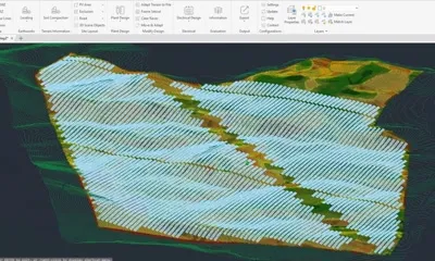


Solar farm design software automates the layout, grading, and electrical design of utility-scale photovoltaic plants. Unlike generic CAD tools or cloud-only platforms that lose terrain fidelity, PVX.Cad is AutoCAD-native PV design software built for the complexity of solar farms on real terrain: slope analysis, grading optimization, cable routing, and construction-ready outputs from one file.
Why solar farm designs get reworked at construction
On sloped sites, earthwork accounts for 15-40% of total solar farm project cost. With interconnection queues pushing developers to more complex terrain, the gap between design assumptions and construction reality is growing. Engineering teams stretched thin cannot afford weeks of rework.
Multiple disconnected tools
Terrain data exported from CAD, processed in a separate PV design tool, results manually transferred back. Every handoff introduces data loss, version mismatches, and rework.
Simplified terrain models
Cloud-based solar farm software compresses your topo surface to run on their servers. Full-resolution detail from LiDAR or drone surveys gets lost before the design starts.
No construction-ready outputs
The design tool produces layouts. Construction needs DWG files, pile coordinates, grading contours, and cable schedules. The gap between design output and IFC documentation is filled manually, introducing errors.
PVX.Cad: one tool, one file, construction-ready
Analyze terrain before layout
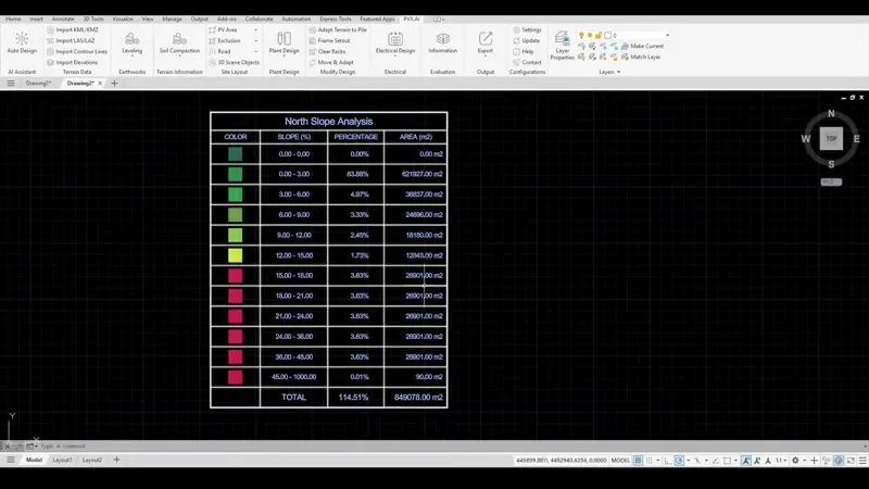
Reconstruct a grid surface from your terrain data at configurable resolution. Slope analysis and soil hardness classification run before a single row is placed.
Three grading approaches in minutes
Full-terrain smoothing, pile-adaptive grading, and table splitting compared side by side with real cost calculations. Choose the right approach for each site.
Cable topology comparison with voltage drop
Automated routing for Line, U-String, and Leapfrog topologies. Voltage drop calculated per string, per cable cross-section. On one 130 MWp project, the topology choice saved $430K.
Clean PVsyst export + construction package
DWG for construction, PVsyst-compatible data with module-by-module positions for yield simulation, and CSV/XLS schedules for earthworks, piles, cables, and procurement. All from one AutoCAD project.
See PVX.AI in action
Watch how solar engineers use PVX.AI to cut earthwork costs and shorten cable runs before breaking ground.
How PVX.Cad compares
| PVcase | Cloud tools (PVFARM, RatedPower) | PVX.Cad | |
|---|---|---|---|
| Environment | AutoCAD + BricsCAD | Browser | Inside AutoCAD |
| Terrain resolution | Layout-first | Server-constrained | Full local resolution |
| Grading comparison | Basic | Single approach | 3 approaches side by side |
| Cable optimization | Basic routing | Limited or none | 3 topologies, per-string voltage drop |
| Construction output | DWG export | PDF, CSV exports | Native DWG/DXF, earthworks and pile-coordinate CSV |
| Your data | On your machine | On their servers | Never leaves your machine |
| Construction rework | Layout-first, grading after | Design assumptions vs. site reality | Terrain-verified, construction-ready from day one |
Real numbers from real solar farm projects
$727K
Earthwork cost savings
70% less earthwork volume (118K to 35K m3) by comparing 3 grading approaches on one project.
Read case study →$430K
Cable cost reduction
14% shorter cable runs via multi-topology comparison across 338 DC combiners at 130 MWp.
Read case study →"PVX.AI cut our engineering time in half while improving layout precision. On hilly terrain, the automated pile length and slope checks eliminated manual iteration entirely."

Hakan Ozen
Structural & AEC Engineer · ISOTEC
"We adopted PVX.AI mid-project and it picked up our existing layout without losing a step. It handled grading and routing automatically and caught an excavation issue that would have been costly to fix in the field."

Hatice Elif Beyazitli Celik
Analysis & Projecting Process Leader · EnerjiSA
Whether designing a 10 MW solar farm or a 500 MW solar power plant, PVX.Cad processes your full-resolution terrain data locally. 3.8 TWp of utility-scale photovoltaic capacity designed across 40+ countries.
How teams use PVX.AI
See PVX.Cad on your terrain data
Send us your DWG or topo file. We auto-design your site in 30 seconds and walk through the grading report together.